Temagami Magnetic Anomaly
O-bawb-ika lake north
|
- Temagami Land is a part of Canadian Shield - one of the largest single exposure of Precambrian rocks in the world, which were formed after the earth's crust cooled.
-
2,736 million ( 2,7 billion) years old
are Older Temagami volcanics, Bowins and Heaman,geologists, found in 1992
-
11,000 years ago, this area was covered by a massive ice sheet, hundreds of metres thick.
-
As the ice melted back towards the north, a huge inland sea (or glacial lake) formed, covering most of the area.
-
This lake lasted for some two thousand years until it drained about eight thousand years ago.
-
Glacier left deep lakes behind, scraped rocks free of plans and trees - but they returned.
|
-
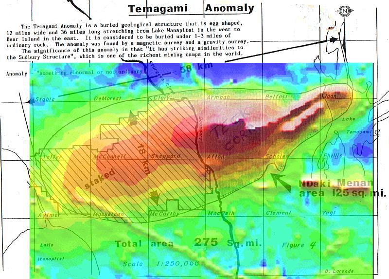
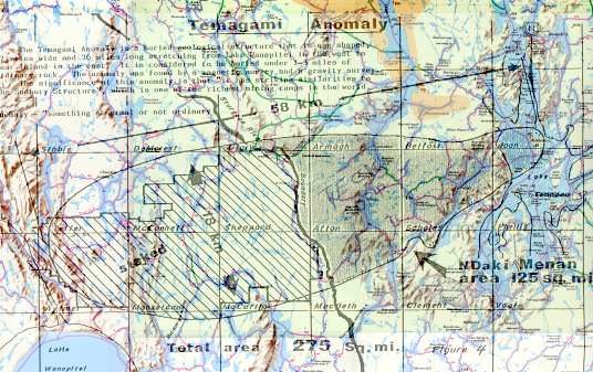
The Temagami Anomaly is a buried geological structure that is egg shaped, 12 miles wide and 36 miles long stretching from Lake Wanapitei in the west to Bear (Makominising) island in the east. It is considered to be buried under 1-3 miles of ordinary rock. The anomaly was found by a magnetic survey and a gravity survey.
-
The significance of this anomaly is that "it has striking similarities to the Sudbury Structure", which is one the RICHEST MINING CAMPS IN THE WORLD.
-
Currently several corporations ( Teck Corporation, TresOr Corporation, DeBeers and others ) which specialize in natural resources extraction plan to exploit the rich resources of Temagami rock, including diamonds.
|
Magnetic map of Temagami Anomaly, one of the largest anomalies in North America
|
|

Magnetic field strength,
nanoTesla
|
Historical Native map and Temagami Anomaly
|
|
Sources:
David Laronde of Meegwich Consultants Inc., Temagami
Craig MacDonald
Continental Geoscience Division of Natural Resources Canada
W.R.Church
Hallowell A.
"Ojibway Ontology,Behaviour and Worldview. 1981
Last updates made in March 2005
 Neodim Kollobok. Temagami, 2002-2005